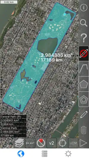
从卫星视图测量土地、道路、公园、国家、湖泊等。 计算距离、区域和周长。
此应用程序提供大多数竞争对手没有的功能:
- 添加自定义的距离和面积单位。
- 绘制室内多边形。 例如,土地面积与水体中删除。
- 将点添加到路径的中间 (大部分只允许您将添加到路径末尾) 自来水将添加到路径的结尾。 长按要添加到中间的一条道路。
- 交换路径或多边形中的两个点。
- 从 GPS 接收机添加您当前的位置。
特点:
- 3 的地图图层选项
- 导出和导入.kml 文件通过 Dropbox、 iCloud、 电子邮件等
- 引脚可拖动并手动编辑
- 名称,注意到,并颜色每个路径和多边形的字段
- 通过电子邮件或文本消息路径和多边形数据
- 4 详细模式。 仅查看要查看的信息
- 按邮政编码、 城市、 地址等搜索
- 在地图上的点附近获取地址
4 种绘图模式:
- 路径
- 多边形
- 与空心空格内多边形
- 没有编辑模式 (以防止意外编辑)
显示路径的值:
- 总距离
- 每个航点的增量距离
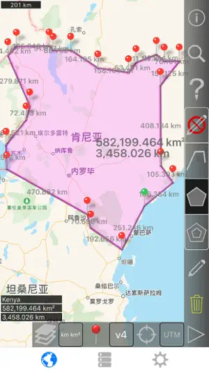
对于多边形显示的值:
- 地区
- 外围
- 为每个边的的距离
将点添加到路径或多边形中的四种方法 1:
- 点击地图
- 使用您当前的位置
- 手动输入坐标
- 导入.kml 文件
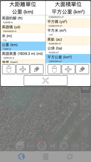
默认距离单位包括:
- 米
- 英尺
- 码
- 公里
- 英里
- 航海里程
默认地区单位包括:
- 平方公尺
- 平方尺
- 平方码
- 平方千米
- 平方英哩
- 平方海里
- 平方英亩
- 平方公顷
坐标格式:
- 度
- 度,分钟
- 度,分钟秒
- UTM / UPS (通用横向墨卡托) / (通用极性立体)
- MGRS(军用电网参考系统)
English:
Measure land, roads, parks, countries, lakes, etc from a satellite view. Calculates distances, areas, and perimeters.
Features that this application offers that most competitors do not:
- Add custom distance and area units.
- Draw interior polygons. For example, land area with bodies of water removed.
- Add a point to the middle of a path (Most only allow you to add to the end of the path) Tap to add to the end of a path. Long press to add to the middle of a path.
- Swap two points in a path or polygon.
- Add your current location from GPS receiver.
Features:
- 3 map layer options
- Export and import .kml files via Dropbox, iCloud, email, etc
- Pins are draggable and manually editable
- Name, notes, and color fields for each path and polygon
- Email or text message path and polygon data
- 4 verbosity modes. See only the information that you want to see
- Search by postal code, city, address, etc
- Get addresses near point on map
4 drawing modes:
- Path
- Polygon
- Polygon with hollow spaces inside
- No edit mode (to prevent accidental edits)
Values displayed for paths:
- Total distance
- Incremental distance for each waypoint
Values displayed for polygons:
- Area
- Perimeter
- Distance for each side
Add points to a path or polygon in 1 of 4 ways:
- Tap on the map
- Use current location
- Enter coordinates manually
- Import .kml file
Default distance units include:
- Meter
- Foot
- Yard
- Kilometer
- Mile
- Nautical mile
Default area units include:
- Square meter
- Square foot
- Square yard
- Square kilometer
- Square mile
- Square nautical mile
- Square acre
- Square hectare
Coordinate formats:
- Degrees
- Degrees, minutes
- Degrees, minutes, seconds
- UTM / UPS (Universal Transverse Mercator) / (Universal Polar Stereographic)
- MGRS (Military Grid Reference System)
版本更新内容:较新版本的兼容性修补程序。\n\nEnglish:\nCompatibility fix for newer iOS versions.\n\nPlease send crash reports if crashes occur.\nPlease contact the developer via email if you have questions or notice any errors or issues.


ICAO英语学习系统总共13款应用
本APP为NWATM定制,旨在提高NWATMB在职管制员应用管制员英语语言的综合能力、使用管制员英语进行通讯的能力,以及使用管制员英语针对一些特殊情况的处理能力


Greenbelt雲端控制
效率
Vesli Negocios
效率
小鹿声文-录音转文字实时语音翻译
效率MailBus - Email Messenger
效率酒店公寓管理
效率支票易
效率BudLabs
效率
专注清单: 番茄钟 & 任务清单
效率FSXF会务
效率
音量和地区计算器 - 工程工具包
效率